Bring Maps to Life with Windows!
Maybe it's just me, but I think this is pretty friggin cool...
I just finished putting the final touches on the new "window" function. The purpose of this function is to provide some more flexibility over what you can display in the context of the map. Specifically it was meant to allow people to display panoramic photos in a map, like the ones Dr Andrew Hudson-Smith has taken of London.
Dr. Hudson-Smith's Digitally Distributed Environments Blog
In fact, Dr. Hudson-Smith visited San Francisco a couple of weeks ago and I had the pleasure of driving him around to take a few panoramics of San Francisco. We were only able to take four pictures, and he has only had time to convert two of them into the quicktime format, but I am just too eager to show off this new functionality, so I went ahead and made a map of the two pictures. I'll be adding in others as he finishes them.
Example Panoramic Map
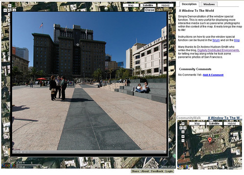
The panoramics are not hosted on CommunityWalk. I don't yet offer a solution for that. Instead the window function allows you to display anything you want on the map using an IFrame. This allows you to display any other website in the context of the map.
I decided to do it this way so that you would have the maximum flexibility over what content you displayed and so that you can provide more explanation about these links to your viewers. This explanation may be something like "Requires Quicktime" or "May take a moment to display", etc.
You can choose to display the IFrame with or without scroll bars and with or without a larger view. You can also designate a maximum size for the larger view. You can find more extensive instructions for this functionality in the forum.
More Extensive Instructions
There may very well be some bugs with this and I'd love to hear any feedback people have. So please leave comments or drop me an email to report bugs or let me know what you think!
I just finished putting the final touches on the new "window" function. The purpose of this function is to provide some more flexibility over what you can display in the context of the map. Specifically it was meant to allow people to display panoramic photos in a map, like the ones Dr Andrew Hudson-Smith has taken of London.
Dr. Hudson-Smith's Digitally Distributed Environments Blog
In fact, Dr. Hudson-Smith visited San Francisco a couple of weeks ago and I had the pleasure of driving him around to take a few panoramics of San Francisco. We were only able to take four pictures, and he has only had time to convert two of them into the quicktime format, but I am just too eager to show off this new functionality, so I went ahead and made a map of the two pictures. I'll be adding in others as he finishes them.
Example Panoramic Map
The panoramics are not hosted on CommunityWalk. I don't yet offer a solution for that. Instead the window function allows you to display anything you want on the map using an IFrame. This allows you to display any other website in the context of the map.
I decided to do it this way so that you would have the maximum flexibility over what content you displayed and so that you can provide more explanation about these links to your viewers. This explanation may be something like "Requires Quicktime" or "May take a moment to display", etc.
You can choose to display the IFrame with or without scroll bars and with or without a larger view. You can also designate a maximum size for the larger view. You can find more extensive instructions for this functionality in the forum.
More Extensive Instructions
There may very well be some bugs with this and I'd love to hear any feedback people have. So please leave comments or drop me an email to report bugs or let me know what you think!
posted by The Entreprexplorer at
6:22 PM
![]()


12 Comments:
Thanks for the update on the new window feature. Like you, I couldn't wait and have updated my links to use the new feature. The options for a small and large window work nicely, as is the ability to create multiple links in one post.
The use of Quicktime over java is probably prefereable in this instance, especially for the performance in larger windows.
The only problem I had was that some of my locations disappeared from the map while I was editing them and I had to refresh the page to get them to display again. I haven't had any problems viewing though.
Now I just have to get off my bum and convert some more of my panoramas to QTVR ;-)
By Anonymous, at 6:23 PM
This is a good feature, thank you Jason. Yesterday I've played around with www.MapBuilder.com, they have also realized some good ideas around Google Maps.
By Anonymous, at 1:42 AM
I'm guesing you've made some changes, as the disappearing locations haven't happen to me today. Just had a few cases where the numbers didn't appear, or the satellite images didn't load (easily fixed by clicking Map, then Satellite).
I've started making up some modified pages on my existing site to provide the link for my panoramas here. This way I still get the functionality of my java applet and don't have to convert all of my files. Being able to restrict the window size is handy since the performance of the applet is proportional to it's size on screen.
Now I'm having some serious fun!! :-)
By Anonymous, at 4:10 PM
I think my problems were related to a very busy processor. I forgot I was still running some rendering in the background from yesterday. Seems to be working just fine (adding locations with the 'window' option) in IE6 then.
By Anonymous, at 6:56 PM
OK, I've converted a substantial portion of my panoramas from my site to use this feature. Now to turn the really cool into really really cool. Creating hotspots that load the different panoramas for one location is one thing, but then I though "Why not link to 'nearby' locations as well?"
I've nutted out linking hotspots to different locations by specifying the url with a target frame of "_top".
Temporary test location at
http://tinyurl.com/cv635
Is there a better way to link betwen locations? I can also assign a javascipt function as a hotspot action if that helps. The disadvantage with the method I described is that it breaks the functioning of the "Return to the last result button".
By Anonymous, at 3:08 PM
Ben,
In general you can link between locations within the application, but I'm not sure if it is going to be possible to link between them from the iframe. I'll have to look into this some more and let you know.
By Anonymous, at 8:07 PM
Hi Jared
I saw the internal links just after I posted, but looking at the source code at the client end it was probably a bit too optimisitic from an external document. The URL option works reasonably well, especially being able to record all of the screen layout options. This is especially useful where different locations have different resolutions of satellite imagery available.
I had a play with Google Earth for the first time (using the .kml from my site) and this is also very cool. The hidden code for the new window shows up in this which is a bit messy. Is it possible to have this parsed more neatly before the .kml file is sent to the client?
e.g. Text: URL
(enlargement URL if it exists otherwise the first URL, or text and url on separate lines)
Is it possible to also to organise the links into the same categories within the .kml as the currently selected option in the CW site? This would "put the icing on the cake" for this aspect of CW.
Now if only I could link the pan angle on a panorama to the oblique 3D view in Google Earth to have synchronised panning. Now that would be cool. ;-)
By Anonymous, at 5:37 PM
Ben, thanks for pointing out the kml. I will get that cleaned up. What I will probably do is have the link display as it does in CW but then open up the panorama in the included Google Earth browser.
I would love to make Google Earth reflect the CW categories, but I am not sure how to yet. I bet there is a way, I just might need to be a bit creative about it. It might be a little while before I can find a decent solution, but I will look into it.
Thanks for the suggestion!
By Anonymous, at 8:30 PM
btw Ben, those are some amazing Panoramics you have taken! If I ever get out to Australia it'll be great to have your map as a little tour guide!
By Anonymous, at 8:32 PM
I looked at a kml file saved from Google Earth (zipped XML) and compared it to a file from CW and all it seems to need is a nested <folder>,<name> pair for each sub folder. Sounds easy but then I don't know what's required at your end to sort the locations and output the kml in the first place.
Using the Google Earth browser pane as you suggested is probably the simplest and works quite well with the files prepared for CW e.g..
PS. Glad you liked the panos ;-)
By Anonymous, at 8:11 PM
Ben,
I cleaned up the kml to include the panoramic links. I also began putting in place some organization folders. Currently they only correspond with the categories, but I am going to mkae them correspond to the topics and subcategories as well.
I looked at your map with it and I think it looks a lot cleaner like this. Thanks for the suggestion!
By Anonymous, at 10:48 PM
Thanks Jared. Those changes are a big improvement. It's great having the two options available from the one set of data.
By Anonymous, at 3:19 PM
Post a Comment
<< Home